发布时间:2025-06-18 打印
北美地形对大气冬季环流和降水的影响
The Influence of North American Topography on Atmospheric Winter Circulation and Precipitation
It has long been known that North America’s mountains play a key role in shaping Northern Hemisphere atmospheric winter circulation and precipitation. However, much remains to be understood within this subject. Here, we further investigate how North America’s topography alters winter (December–March) circulation and precipitation by performing and exploring a series of general circulation model experiments with altered topography over North America and analyzing observations. We find that the mountains of western North America divert the large-scale midlatitude westerly flow, leading to an anomalous ridge over the northern Rockies and a broad anomalous trough extending from southwest of the United States to eastern North America and the northwest Atlantic, contributing significantly to the observed high-amplitude atmospheric wave pattern over North America. The blocking and diversion of large-scale subtropical easterly flow by Mexico/Central America’s mountains also have a substantial impact on large-scale circulation, contributing to a realistic separation of the North Atlantic and Pacific subtropical anticyclones. North American topography leads to strongly enhanced precipitation along the western slopes of the Rocky Mountains and eastern slopes of Central America where the large-scale low-level flow is forced upslope, with a drying over the interior of North America and a notable wetting over the southeast United States, where precipitation is increased by more than 100% in some areas when realistic topography is incorporated. In this work, we perform an in-depth dynamic analysis of our topography experiments and show how the simulated impact of North America’s topography is consistent with observations.
北美山脉在塑造北半球冬季大气环流和降水方面发挥着关键作用,然而还有许多有待了解的地方。本文通过对北美地区地形变化条件下的大气环流模式试验和观测数据分析,进一步探讨了北美地形对冬季(12 - 3月)环流和降水的影响。
研究发现,北美西部的山脉使中纬度大尺度西风气流改道,导致了落基山脉北部的异常脊和从美国西南部延伸到北美东部和大西洋西北部的广泛的异常槽,对观测到的北美高振幅大气波型有重要贡献。墨西哥/中美洲山脉对副热带大尺度东风气流的阻塞和分流也对大尺度环流产生了重大影响,有助于北大西洋和太平洋副热带反气旋的实际分离。北美地形导致落基山脉西坡和中美洲东坡的降水强烈增强,其中大规模低空气流被迫上坡,北美内部干燥,美国东南部明显湿润,当实际地形结合在一起时,某些地区的降水增加超过100%。研究对地形实验进行了深入的动态分析,且表明北美地形的模拟影响如何与观测结果相一致。
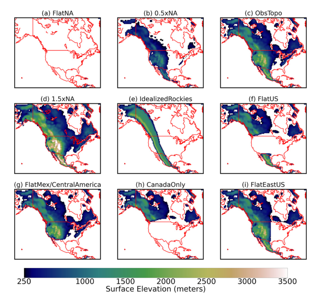
Fig. 3.Gridbox surface elevation used in climate model topography experiments. Only values greater than 250 m are shaded.
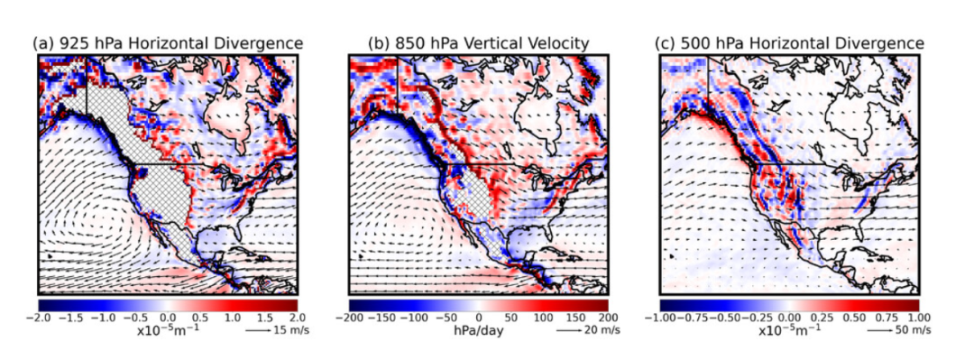
Fig. 8.December–March ObsTopo wind (vectors) and ObsTopo–FlatNA change in (a) horizontal divergence at 925 hPa, (b) vertical velocity at 850 hPa, and (c) horizontal divergence at 500 hPa.
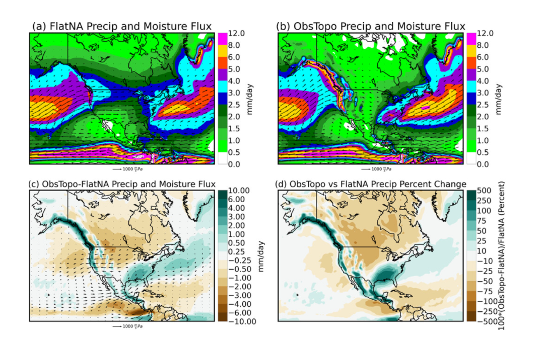
Fig. 15.December–March side-by-side panels of precipitation and vertically integrated moisture flux for (a) FlatNA and (b) ObsTopo. (c) ObsTopo–FlatNA change in precipitation and vertically integrated moisture flux and (d) percent change in precipitation.
延伸阅读:https://journals.ametsoc.org/view/journals/clim/38/10/JCLI-D-24-0284.1.xml
版权信息:Copyright@ 中国气象局图书馆(气象科技史研究中心) 技术支持:北京中科聚网信息技术有限公司
地址:北京市海淀区中关村南大街46号 联系电话:010-68406306 68409247 Email:cmalibrary@126.com

图书馆公众号